Jalan - jalan Belitong (The Belitong Island Journey) We are Travel Agent Belitung Island, in Indonesia.if you interest to have great journey with us..just send a message to my Inbox. then i will reply your email as soon as possible..thank you... ^_^
Saturday, July 31, 2010
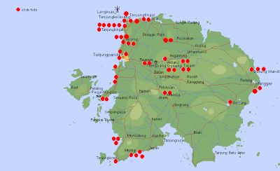
Where Is Belitung Island?????
GEOGRAPHY
Belitong island lies between 107o08' to 107o58' east longitude and 02o30' to 03o15' south latitude.
it has total extent of approximately 229.369 hectare or 2.293,69 km2
In the chart of world, Belitong is well known as BILLITONIT. the equator of east to west is approximately 79 km while the equator of north to south is about 77 km. Belitong Regency is lined :
1. by South China Sea at North
2. by East Belitong Regency at East
3. by Gaspar Strait at West
4. by Java sea at South. LOCAL GOVERNMENT OF BELITONG
Tanjungpandan is the capital city of Belitong Regency which has 5 Districts, 40 Villages and 2 Suburb administration. They are can be grouped as follows :
1. Membalong consist of 12 villages
2. Tanjungpandan consist of 10 villages and 2 town administration
3. Badau consist of 6 Villages
4. Sijuk consist of 8 Villages
5. Selat Nasik consist of 4 villages
The total is 40 villages and 2 town administration
Subscribe to:
Post Comments (Atom)

No comments:
Post a Comment